Eritrea – Facts, Capital & Geography | Random Country Generator
Capital
Asmara
Population
3.6 Million (#129)
Currency
Eritrean Nakfa (ERN)
Language
Tigrinya, Arabic
Area
117,600 km²
National Dish
Zigni
National Flower
None official
Density
55/km²
Internet TLD
.er
Brief History
Eritrea was part of the ancient Kingdom of Aksum before falling under Ottoman and later Italian colonial rule in 1890, which defined its modern borders. Following British administration after WWII, it was federated with Ethiopia in 1952, which subsequently annexed it in 1962, sparking a 30-year war of independence. Eritrea achieved formal sovereignty on May 24, 1993, under Isaias Afwerki, who has ruled the country as a single-party state ever since.
Key Demographics & Capital
Eritrea has a population of approximately 3.6 million, composed of nine recognized ethnic groups, with the Tigrinya (55%) and Tigre (30%) being the largest. The country has no official language, though Tigrinya, Arabic, and English are widely used in administration and media. Low life expectancy and high emigration rates, particularly among young men escaping indefinite national service, have created large diaspora communities.
Geography
Eritrea is in the Horn of Africa along the Red Sea coast. The landscape ranges from the highland plateau (where Asmara sits at 2,325m) to the hot Danakil Depression — one of the lowest and hottest places on Earth. The Red Sea coastline stretches over 1,000 km with the Dahlak Archipelago offshore.
Culture & Tradition
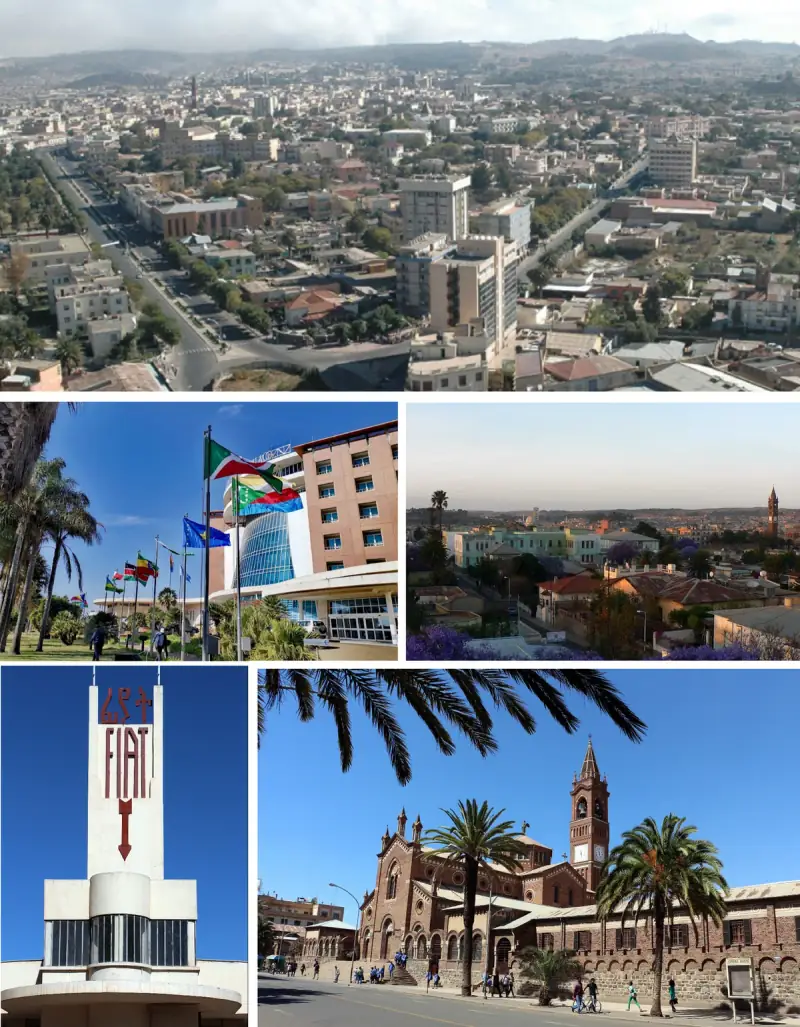
Eritrean culture reflects nine ethnic groups with diverse traditions. The Tigrinya and Tigre are the largest groups. Italian colonial heritage is visible in Asmara's remarkable Art Deco architecture and cuisine (coffee culture, pasta). Traditional music, dance, and coffee ceremonies are important social rituals.
Economy
Eritrea's economy is primarily based on subsistence agriculture and mining (gold, copper, zinc). The country has potential for tourism and fisheries. International sanctions and border conflicts have limited economic development. Remittances from the diaspora are an important income source.
Travel Highlights
Explore Asmara's stunning Italian Art Deco architecture (UNESCO), ride the vintage railway through mountains, dive in the pristine Dahlak Archipelago, visit the ancient ruins of Adulis, and experience the Danakil Depression's extreme landscapes. Eritrea is one of the least-visited countries in the world.
Fun Facts
Asmara's Art Deco architecture is a UNESCO World Heritage Site.
Eritrea has never had a national election since independence.
The country has nine recognized ethnic groups.
Eritrea's Red Sea coast has pristine coral reefs.
Italian influence is visible in the cuisine and architecture.
The Eritrean Railway uses original Italian-built steam locomotives.
Map
Bordering & Nearby Countries
Frequently Asked Questions (FAQs)
More from Africa
Want a surprise? Try our random Africa country generator or pick from the entire world.
Algeria
Discover Algeria: Africa's largest country. From Saharan landscapes to Mediterranean coasts, explore ancient ruins and Berber culture.
Angola
Explore Angola: from Kalandula Falls to Atlantic beaches. Discover vibrant culture, wildlife, and Southern African landscapes.
Benin
Discover Benin: birthplace of Voodoo. Explore Dahomey palaces, floating villages, and rich West African traditions.
Botswana
Explore Botswana: home of the Okavango Delta and incredible safaris. Discover elephants, Kalahari landscapes, and African wilderness.