Turkmenistan – Facts, Capital & Geography | Random Country Generator
Capital
Ashgabat
Population
6.3 Million (#109)
Currency
Turkmenistan Manat (TMT)
Language
Turkmen
Area
488,100 km²
National Dish
Plov
National Flower
White Lotus
Density
12/km²
Internet TLD
.tm
Brief History
Turkmenistan was inhabited by nomadic Oghuz tribes and served as a major center along the silk trade route, with Merv once being one of the largest cities in the Islamic world. It was annexed by the Russian Empire in the late 19th century after the Battle of Geok Tepe and later became a Soviet republic in 1925. Turkmenistan achieved independence on October 27, 1991, under Saparmurat Niyazov, who established a totalitarian cult of personality. The nation declared official permanent neutrality in 1995 and has leveraged its massive natural gas reserves to fund state development.
Key Demographics & Capital
Turkmenistan has a population of approximately 6.3 million, with ethnic Turkmen comprising over 85% of the population, followed by Uzbek (5%) and Russian (4%) minorities. Turkmen, a Turkic language, is the official state language, written in the Latin script, while Russian remains common in administrative settings. The population density is low, with residents clustered along the Amu Darya river valley and foothill oases, leaving the Karakum Desert uninhabited. The country maintains a highly controlled immigration and emigration policy.
Geography
Turkmenistan is in Central Asia, with the Karakum Desert covering about 70% of the country. The Kopet Dag Mountains run along the Iranian border. The Amu Darya river forms part of the northeastern border. The Caspian Sea coast is in the west. The landscape is predominantly flat desert with extreme continental climate.
Culture & Tradition
Turkmen culture revolves around carpet weaving (Turkmen carpets are world-renowned), horse breeding (the legendary Akhal-Teke breed), and Islamic traditions. The country has a personality cult around its leadership. Traditional dress includes distinctive telpek hats. Music features the dutar (two-stringed lute). Turkmen cuisine includes plov and çörek bread.
Economy
Turkmenistan has vast natural gas reserves (fourth-largest in the world) which dominate the economy. Cotton production is also significant. The state controls most economic activity. The country has invested heavily in monumental architecture in Ashgabat. Agriculture depends on irrigation from the Karakum Canal.
Travel Highlights
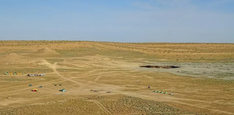
See the flaming Darvaza Gas Crater ('Door to Hell'), explore the ancient Silk Road city of Merv (UNESCO), marvel at Ashgabat's surreal white marble cityscape, visit the ancient Parthian fortress of Nisa (UNESCO), and discover the Yangykala Canyon's colorful formations. Turkmenistan offers truly unique and otherworldly experiences.
Fun Facts
The Darvaza Gas Crater is called the 'Door to Hell' and has been burning since 1971.
Ashgabat holds a Guinness record for the most white marble buildings.
Turkmenistan has the world's fourth-largest natural gas reserves.
The Akhal-Teke horse breed is the country's national emblem.
Turkmenistan is one of the most isolated countries in the world.
The ancient city of Merv was once one of the world's largest cities.
Map
Bordering & Nearby Countries
Frequently Asked Questions (FAQs)
More from Asia
Want a surprise? Try our random Asia country generator or pick from the entire world.
Afghanistan
Discover Afghanistan: Hindu Kush mountains and ancient Silk Road heritage. Explore Bamiyan Valley, Herat's architecture, and Afghan culture.
Armenia
Explore Armenia: first Christian nation. Discover ancient monasteries, Lake Sevan, and Caucasus mountain heritage.
Azerbaijan
Explore Azerbaijan: Land of Fire. Discover Baku's Flame Towers, ancient walled city, mud volcanoes, and Caspian Sea heritage.
Bahrain
Explore Bahrain: ancient Dilmun heritage and modern Gulf culture. Discover pearl diving history, Formula One, and island archipelago charm.